Accurate measurements don’t just help you price a job, they also help you justify your bid to prospects and avoid costly rework later. On Plato, you can view layer-wise measurements for each property directly on your mobile device.
What is the Layers Panel?
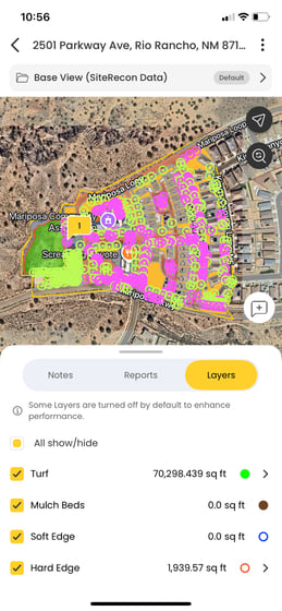
When you open a property in Plato, you’ll see a panel at the bottom of the screen. The Layers section within this panel shows:
- Measured features on the site
- Parcel information
- Imagery details
- Layer-specific measurements
Steps to View Layer-Wise Measurements
1. Open Your Property Map
- From the dashboard, locate your property.
- Use Search or filter existing properties if needed.
- Or go directly to the property using Open your property map
2. Tap the Layers Panel
- Look for the Layers icon in the bottom panel
- Tap to expand the list of features measured on the property
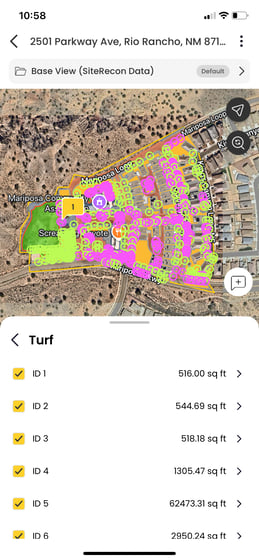
3. Select a Layer to View Measurements
- Tap any layer name to see its measurement details
- You’ll see values such as square footage, linear feet, or counts depending on the feature
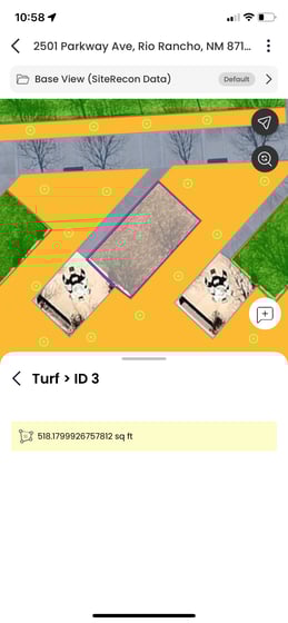
Alternate Option: Tap the Map
You can also tap directly on a mapped feature (e.g., a turf area or tree icon) to instantly view its measurement data on the screen.
How This Helps You in the Field
Being able to review exact measurements—layer by layer—means you can:
- Confirm bid accuracy before sending
- Answer client questions on the spot
- Avoid miscommunication with production teams
- Feel more confident in every site walkthrough