
What Scout returns
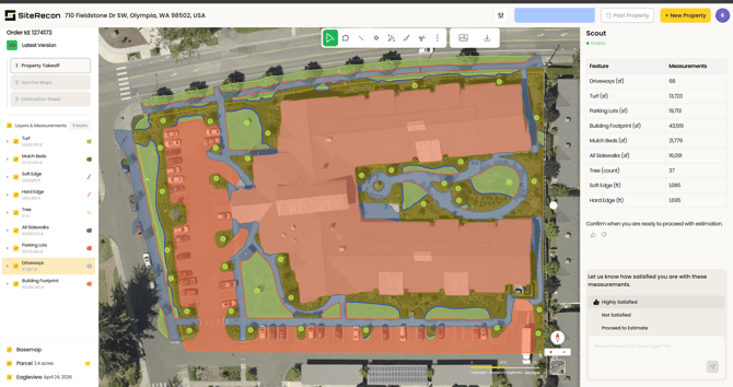
Every Scout measurement is a multi-layer takeoff of the property, broken out by service area based on the package you chose:
- Lawn Care — Turf, Mulch, Soft Beds
- Landscape — Turf, Mulch, Soft Beds, Hard Edge, Tree, Parking Lot, All Sidewalks (covers public and private sidewalks)
- Snow — Sidewalks, Parking Lots, Driveways
- Custom — Custom select: exactly the layers you choose
Each layer shows its measured area, so your bid reflects actual service scope — not a single parcel total. The imagery capture date is displayed on every property, so you always know how current the view is.
Reading your layers
- Toggle individual layers on and off to inspect each service area
- Area layers (Turf, Mulch, Sidewalks, Parking Lots, Driveways) display in square feet
- Edge layers (Soft Edge, Hard Edge) display in linear feet — ready for line trimming and edging quantities
- Trees display as a count
- Parcel size displays in acres, alongside the imagery source and capture date
How accurate are Scout measurements?
SiteRecon's AI measurements are most commonly between 93–98% accurate for properties with clear aerial visibility.
What affects accuracy:
- Tree canopy or shadow covering ground features
- Site changes newer than the imagery capture date
- Complex or ambiguous boundaries between service areas
Scout measurements are fully AI-generated — they don't include the expert QA review that comes with SiteRecon's Done-For-You takeoffs (available on Growth, Teams, and Partner plans). That's why the self-review step matters: check each layer against the imagery, and use free self-measurement editing to fine-tune anything that looks off.
You can also give every measurement a thumbs up or thumbs down right in Scout — that feedback loop helps Scout calibrate and deliver even better accuracy over time.
How acreage is counted against your plan
- Paid account credits are billed on parcel acre size, rounded up to the nearest acre. Example: a 3.2-acre parcel with the Lawn Care package is billed as 4 acres or 4 measurement credits.
- Editing your measurement after it's returned doesn't cost additional credits.
Using your results
From any measured property you can:
- Run a benchmark takeoff and estimate using SiteRecon's standard production rates and quantities. (Custom production rates and takeoff resource settings are available on Growth, Teams, and Partner plans.)
- Export to XLS — measurement details, takeoff quantities, and estimation outputs or export a map image (.png).
- Return anytime — measured properties stay in your account with no storage limit.