---
title: Running a Measurement with Scout
description: Everything you need to run your first property measurement and understand how your Scout plan works.
---
[Skip to content](https://help.siterecon.ai/scout-ai-measurements-overview#main-content)
English - United States
Show submenu for translations

Open main navigation
Close main navigation
- English - United States
Show submenu for translations
- [Contact us](https://meetings.hubspot.com/shubham106/csmproduct)
[Contact us](https://meetings.hubspot.com/shubham106/csmproduct)
Hi, how can we help?
- There are no suggestions because the search field is empty.
1. [SiteRecon University](https://help.siterecon.ai/?hsLang=en-us)
2. [Scout AI](https://help.siterecon.ai/scout-ai?hsLang=en-us)
# Running a Measurement with Scout
## How to submit a property, choose the right measurement package, and get bid-ready data back in minutes.
### **Before you start**
Every Scout plan includes plan allocated measurement credits:
- **Pricing:** 1 property measurement credit per acre.
- **Acreage basis:** parcel size, **rounded up to the nearest acre** — a 3.2-acre property is billed as 4 acres
- **Paid measurement limit:** up to 30 acres per property on Scout Mini $39, up to 50 acres on Scout Pro $79
- Unused monthly credits expire at the end of each cycle
Scout supports property addresses in the United States and Canada.
#### ****
#### **Step 1: Enter the property address**
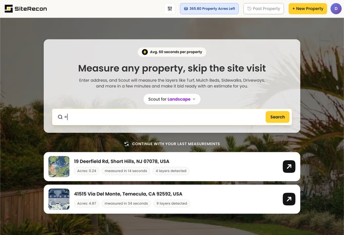
Enter the full street address of the property you want to measure. Scout locates the parcel on aerial imagery, with the imagery capture date displayed.
##### **Tips for best results:**
- Use the complete address, including city and state
- For properties without a standard address (new construction, large campuses), drop a pin to mark the property manually
- Confirm the highlighted parcel matches the property you intend to bid before submitting — paid measurements use credits once submitted
#### **Step 2: Choose your measurement package**
Scout offers 4 preset measurement layer bundles:
| **Package** | **Layers included** | **Measurement Credit cost per acre** |
| --- | --- | --- |
| Lawn Care | Turf, Mulch, Soft Beds | 1 |
| Landscape | Turf, Mulch, Soft Beds, Hard Edge, Tree, Parking Lot, All Sidewalks (covers driveways + sidewalks) | 1 |
| Snow | Sidewalks, Parking Lots, Driveways | 1 |
| Custom | Custom select — choose exactly the layers you need | 1 |
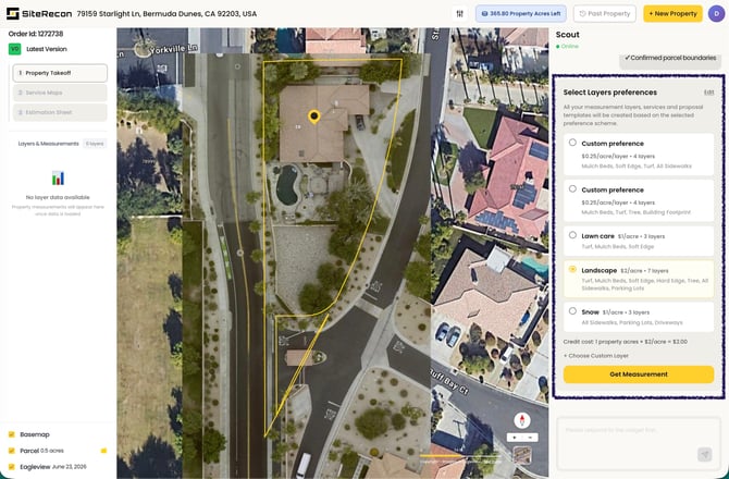
Choose the bundle that matches the service you're bidding — or you can build your own with **Custom**, selecting only the layers you’ll need or use.
#### **Step 3: Review your measurement**
Scout returns most measurements in minutes — and you don't have to wait around. You can leave the platform while a measurement processes; you'll receive an email with a link to the property when it's complete.
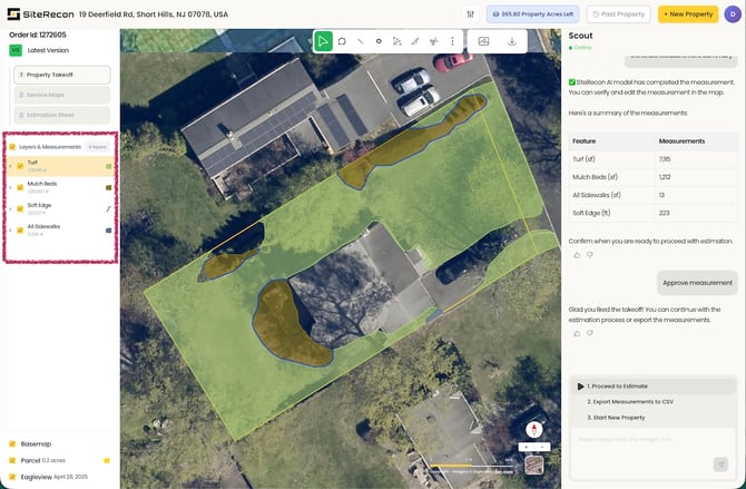
**From your property view you can:**
- Toggle each measurement layer on and off
- See area totals by layer
- Give the measurement a thumbs up or thumbs down — your feedback helps Scout calibrate and improve accuracy over time
- Fine-tune boundaries with self-measurement editing, at no cost
- Run a standard benchmark takeoff and estimate
- Export your measurement to XLS, or export a map image (.png)
Your measured properties are stored in your account with no storage limit.
### **Property types and known limits**
Scout performs best on properties with clear aerial visibility — residential lots, commercial sites, HOAs, office parks, retail, schools, and municipal properties.
#### **Situations that can affect results:**
- Heavy tree canopy covering ground-level features
- Site changes newer than the imagery capture date shown on the property
- Property size limits: paid measurements cover parcels up to 30 acres (Scout $39) or 50 acres (Scout $79); free properties cover up to 20 acres
### **What a measurement costs — worked examples**
- A 3.2-acre property with the **Lawn Care** package will be rounded up to 4 acres = **4 property measurement credits**
- The same property with the full **Landscape** package (7 layers) will be rounded up to 4 acres = 4 property measurement credits
- **If you run out of credits:** Credits can't be topped off mid-cycle on Scout plans. You can upgrade from $39 to $79 inside your account (prorated), or move to a Growth, Teams, or Partner plan by [contacting sales](https://order.siterecon.ai/speak-to-sales) via chat, phone, or [sales@siterecon.ai](mailto:sales@siterecon.ai).
- [Introduction](https://help.siterecon.ai/introduction?hsLang=en-us)
- [Getting started](https://help.siterecon.ai/getting-started?hsLang=en-us)
- [Order Property Measurements](https://help.siterecon.ai/order-property-measurements?hsLang=en-us)
- [Mapping Tools](https://help.siterecon.ai/mapping-tools?hsLang=en-us)
- [Property Map and Data](https://help.siterecon.ai/property-map-and-data?hsLang=en-us)
- [Sharing and Exports](https://help.siterecon.ai/sharing-and-exports?hsLang=en-us)
- [Plato - SiteRecon's Mobile App](https://help.siterecon.ai/plato-siterecons-mobile-app?hsLang=en-us#main-content)
- [Site Audits (SQA) in Plato](https://help.siterecon.ai/plato-siterecons-mobile-app?hsLang=en-us#site-audits-sqa-in-plato)
- [Notes on Plato](https://help.siterecon.ai/plato-siterecons-mobile-app?hsLang=en-us#notes-on-plato)
- [Find Your Property](https://help.siterecon.ai/plato-siterecons-mobile-app?hsLang=en-us#find-your-property)
- [Using Offline](https://help.siterecon.ai/plato-siterecons-mobile-app?hsLang=en-us#using-offline)
- [Property Views](https://help.siterecon.ai/plato-siterecons-mobile-app?hsLang=en-us#property-views)
- [Plato AI Image Generator](https://help.siterecon.ai/plato-siterecons-mobile-app?hsLang=en-us#plato-ai-image-generator)
- [Using Notes on Web Platform](https://help.siterecon.ai/using-notes-on-web-platform?hsLang=en-us)
- [Integrations](https://help.siterecon.ai/integrations?hsLang=en-us)
- [Admin Controls](https://help.siterecon.ai/admin-controls?hsLang=en-us)
- [Estimation](https://help.siterecon.ai/estimation?hsLang=en-us)
- [Product News](https://help.siterecon.ai/product-news?hsLang=en-us)
- [Scout AI](https://help.siterecon.ai/scout-ai?hsLang=en-us)
[](http://siterecon.ai)
[mailto:info@siterecon.ai](mailto:info@siterecon.ai)
Copyright © 2025, SiteRecon Inc.