The SiteRecon map offers multiple ways to interact with property data. You can toggle and adjust layers to customize your view, making it easier to explore site details and understand key measurements. This dynamic navigation panel helps you access the full depth of map data with precision and control.
1. Layer styling
A property map often contains multiple layers, which can make it difficult to distinguish between them. SiteRecon allows you to customize individual layers to make them visually stand out. Here’s how:
1. Select the layer you want to style from the layer panel by left-clicking on it once. This opens a Layer Styling pop-up where you can customize the layer’s appearance. (Refer to the image below)
2. Expand the styling menu by clicking the dropdown arrow in the pop-up.
3. Choose a style from the Style Options, including the most recently used ones.
2. Hiding/showing layers
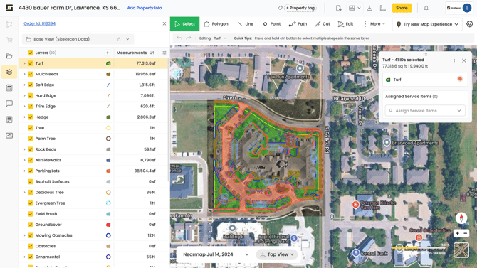
3. Interacting with maps and layers
SiteRecon enables real-time interaction between the map and the layer panel, making it easier to identify and locate specific elements on a property.
- When you select a layer ID from the layer panel, the corresponding area on the map will be highlighted instantly.
- Similarly, hovering over a layer ID in the panel (using a mouse or touchpad) will highlight that section on the map, helping you quickly locate it. (Refer to the picture below.)
- This interaction also works in reverse—with one exception:
If you click directly on a layer ID on the map, the corresponding entry in the layer panel will be highlighted. However, hovering over the map layer will not trigger a highlight in the panel.
4. Finding estimates for your clients
You can quickly generate rough estimates for clients by selecting specific features within a layer and calculating their combined measurements.
- Select one or more IDs from a feature layer to view the total area or length covered. This aggregate value can be used for cost or time forecasting.
- If your service pricing is area-based, multiply the total area by your rate per square foot to estimate the cost.
- To estimate time required, divide the total area by your production rate (area per hour).
- To calculate totals for the entire layer, simply click the checkbox in the layer panel to select all feature IDs at once. The combined measurements will be displayed automatically.
5. Navigating map
You can explore and adjust your property map using either a mouse or a touchpad. SiteRecon also allows you to switch between different views and orientations for better visibility.
5.1. Navigating with your mouse
- Hold the left mouse button and drag the map to move around the screen.
- Release the button once you’ve arranged the map as needed.
- Right-click on any area of the map to view its coordinate values.
5.2. Navigating with the touchpad
- Hold the left-click on your laptop’s touchpad and drag to move the map.
- Release the click once positioned.
- A right-click on the touchpad will also display the coordinates of the selected surface.
5.3. Street/Satellite view
- You can toggle between street view and satellite view depending on your requirement.
- Click the respective option in the yellow-highlighted box to switch views instantly.
5.4. Zoom in/out
- Scroll the mouse wheel to zoom in or zoom out.
- If you are not using a mouse, place two fingers on the touchpad and slide vertically. You can also perform the zooming action by pinching in and stretching out with two fingers on the touchpad.
5.5. Rotate
- Press Alt/Option + Shift and drag the map clockwise or counterclockwise to rotate.
- Click the compass icon to realign the map to face north.