Skip to content
English - United States
  • There are no suggestions because the search field is empty.

FAQs on order measurement property

Q. If the address pin does not land on your address/if you can’t find the correct address, how do you set the address pin to the proper location?

If the system can't pinpoint the exact property location based on the entered address, follow these steps to manually adjust it:

Option A: Locate Manually Within SiteRecon

a) Click on “Locate Manually.”

b) Drag and drop the pin to the correct location if the area is nearby.

Untitled design (1)-1
 
c) Alternatively, manually enter coordinates (latitude and longitude) if known.
 
Option B: Use Google Maps to Get Coordinates
  1. Go to www.google.com/maps 
460823cae6020b98004c41ac77d74a6ba2a8f3d3ab3f8cc22f8e737dc28011a7f0b403387a76aa8f20f7a7eabfb026638263b55efb344d80317205164fa524b822a682b46ec25a41842f6ec433b0e41160f1104531ed610ffd7f7c5fc40c2397948a1197.png
 
2. In the search bar, enter the address to locate the site.
 
21677ebe54da887b0d50de1e6bf28749135c4047b3262120675586d2b193ce52000f45fb2e5043a7fcc7eeec38378274e9203b96c92705b8075ec4fb3a2b233e9de8713ef88071229544fc52b65a1e0ce03364c1871ebf5f0f507f8fe831025f23cbbfdf.png
 
3. Right-click on the desired point on the map, and select the latitude and longitude (as shown below).
 
705bc13b75f70a9aab14e5d019b1906c0a77b8186027d19d38e4c399c3abe2d6b13855d1ce2e32dd2b935dc0b6a63fde3ffe24f5cb679bb555b4241ea4d11752c4f3d14b919061bae196d1d1f7b917d525d2a451f15963f0c3c40f3fa501d42f77efcb1f.png
 
4. Paste the copied latitude and longitude into SiteRecon’s location field.
 
5. Click Confirm. The pin will now be placed in the correct location on the map.
 

Q. How to edit a parcel in a single or bulk order?

a) To make changes to the existing parcel, Click on the pencil icon next to “parcel confirmed.
 
f5584c7727ae4d1a272175f338f44ce97821c1496f37c508d55592fc9a2aa7692ec4d69de13c4d6680955828b0ae5499106a66d2267a71d0713e2572138ac0f935c662be766f5b76d40f681e9d509a3647c3eb4635060dccaff51abb89124c0d2961e524.png
 
b) Then, you can use the following options to delete an existing parcel, draw a new one, or modify the existing parcel.
 
d91765d3f36c394c4217f4ed0c6667f81afb33b6babeb366501ff4ad0f69b87a7c59931f878d28e8a07a07a0989d7824ac44d70e01e9c51dd69bcf80c829d6ab49e3fd9b819a28b5f735448ce0d32de1b92512ad84a974cb8cccc17aca8f101da874227d.png


Q. How do I create a CSV for a bulk project?

Follow these steps to prepare and upload a valid CSV file for your bulk property order:

a) Download the Bulk Project Sample Sheet from the Bulk Order section.

Screenshot 2025-01-12 at 10.08.31 PM.png
 
b) The sample sheet is view-only. To edit it, go to File > Make a copy and save it to your own Google Drive.
 
Screenshot 2025-01-12 at 10.09.23 PM.png
 
c) Use the Feature Selection Tool in the sheet to fill the Measurements column. Copy the appropriate feature list to each address row as needed.
 
8e01bd7a62b4eac681324be86c9a730dcaddb3529bad744a88458f5ce00748640b9ace40583089a61e0f1cc24148f387caa967d7dd31ac2b93208b6ac2183c43151a939168d30d712a2eba93f34fb7a425acf4af22024a867e0cdbc5ead4e8bc8a45187b.png
 
d) In the Export Sheet tab, paste the address information (address, city, state, pin code, etc.) into the appropriate columns.

Refer to the sample data in the sheet for formatting guidance.

a8777993f59345fdc7e56203623f11e1be326a0430dc1b1a498ef0d9957a963e67e3b4aec5cdb65cc67e0717ef40a2971b50a100a3404affcb8ba7c439a720f8a9e15f7516d0d34d2e4df81e3ec60c3494e171eb3ea8cb4804736708d5427369b9974da8.png
 
e) Once the Export Sheet is complete, download it as a CSV file:

Go to File > Download > Comma-separated values (.csv)

15bb5e5027e998b178e32c611395054bc1480e8dc5ce2470ff76024530ed86fc3133f8f750393f8c257dd589339d6fa5981c133b6ee6306b7afac2f457655338872f860f6dfd94890f532f5909a308244012fe0c7da98e53b07dda7cbed9a700698b75d3.png
 
f) Once the file is uploaded and processed in SiteRecon, click “Confirm” to proceed with placing your bulk order.
 

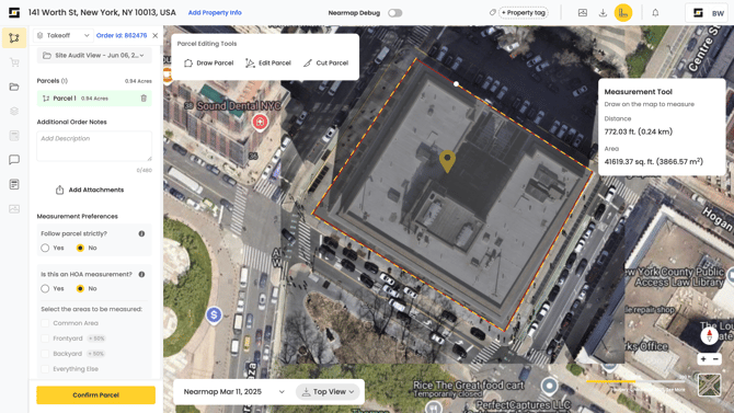
Q. How do I use the measuring tool?

a) To use the measuring tool, select the measuring tool from the top right corner.
 
Untitled design (2)
 
b) Draw the area over the map; measurements will be shown in the Measurement Tool box in the right corner.
 
Screenshot 2025-06-06 at 3.50.54 PM
 

Q. How is the estimated cost calculated for an order?

The cost (credits) for a takeoff order on SiteRecon is calculated using three components:

1. Standard Order Processing Fee

This is a flat fee charged per order for using SiteRecon’s services.

Cost: $3 per order

2. Property Measurement Fee

This fee depends on the area of the property and the number of features selected for measurement.

  • Up to 4 acres: $0.50 per acre, per feature
  • Above 4 acres: $0.25 per acre, per feature
3. Imagery Fee (Nearmap Access)

An additional fee is charged when using Nearmap imagery.

  • Up to 4 acres: $0.50 per acre
  • Above 4 acres: $0.25 per acre
Example Calculation

Scenario: 5-acre property with 2 features selected.

  • Standard Order Processing Fee: $3.00
  • Measurement Fee: 5 acres × 2 features × $0.25 = $2.50
  • Imagery Fee: 5 acres × $0.25 = $1.25

Total Cost = $3.00 + $2.50 + $1.25 = $6.75