Do you need to measure a property's small, segmented, or scattered areas? DIY Measurements lets you do it quickly and accurately without relying on external tools like Google Earth. This feature consolidates all your property maps in one place, helping you streamline your workflow while keeping everything organized.
It’s ideal when you want full control over the measurement process for a few turf patches, mulch beds, or other specific site sections.
It’s ideal when you want full control over the measurement process for a few turf patches, mulch beds, or other specific site sections.
Step-by-step instructions: To Create an Order and Perform DIY Measurements
1. Enter the Property Address
- Input the property address as usual.
- This will load the necessary imagery of the location.
2. Start Drawing Your Parcel
- Draw the required parcel or sections directly on the map.
- Click Confirm Parcel once you’re done.
3. Order Your Self Measurement Takeoff
- After confirming the parcel, you'll move to the order placement screen.
- Make sure no layers are pre-selected at this stage.
- The system will recognize this as a DIY measurement session and assign 0 hours for system-generated calculations.
- Select Self-Measure to proceed.
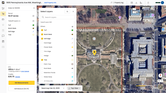
4. Add a New Layer
- Click the ‘+’ button to add a new layer.
- Select the type of area you want to measure (e.g., Turf, Mulch Beds).
- Click Add Layer to Map to continue.
5. Draw and Modify Areas
- Use the Draw Tools to outline the selected feature on the map:
- Use Polygon for shapes like beds or turf areas.
- Use Point for individual elements like trees or hydrants.
- Click around the area to form a polygon. Double-click to complete the shape.
- Adjust your drawing as needed for accuracy.
6. Add More Layers (If Needed)
- To include additional property features, repeat the process:
- Add a new layer.
- Select the type of feature.
- Use the Draw Tool to create polygons for those areas.
7. Finalize the Measurement
- Review all layers for accuracy.
- Save your view once satisfied.
- Your order will now appear as a Self Measured takeoff in your property dashboard.